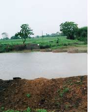
Water in the wells
asr: see Dr. Reddy labs 2009 report they said they had 100% of their water from Rain Water Harvesting RWH , study them how they did it and blog it in detail with numbers so the top 10 Phrama in india can do it( show awareness and presue for other 9 to follow). do Same for other industries with help of CSe.org
asr: see 8 photos on Link on original URL , gives good picture
2) The real learning of this is discuss this with experts ( with website pictures and story facts) and see what other parts of INDIA this can be applied, and contact the local villages , show them this story in IPAD with local language hand-out paper printouts (color)
- show this to Local MLA/MP , and local new papers and university professors and students of the region and mobilize.
- and form Local group and get goverement FUNDS
1. The scourge of water scarcity in Saurashtra
Saurashtra was not always a water-scarce area. People say that water was easily available in the region 10-15 years ago. Ashvin A Shah, a US -based engineering consultant who conducted a survey in 1998 on water availability in the region, says, “The presence of 700,000 dugwells in Saurashtra region indicates the presence of extensive groundwater aquifers throughout the region. This means there is one well for less than 20 people or one well every 300 metres"1.
Shamjibhai Antala of Saurashtra Lok Manch, who has single-handedly worked to recharge over 300,000 wells and tubewells in Saurashtra, says that the groundwater table in most areas of Saurashtra and Kachchh was about 12-15 metres below the surface till the 1960s. However, due to overexploitation of groundwater for irrigation, groundwater has been declining by an average of 2.5 m every year leading to steady intrusion of saline water2. According to G F Joshi, a government official in Rajkot, the groundwater table in these areas has fallen below even 300 metres in some parts of Saurashtra1. As a solution to the water scarcity, people have been digging deeper and deeper, going even up to 600m at which depth it is extremely difficult to recharge as these are confined aquifers2.
While cities get the attention of politicians and thus Rajkot city is now being provided Narmada water, the rural areas continue to face acute water shortages. The entire Saurashtra region had been severely drought-hit since 1985.
2 Worst drought of the century
The drought at the turn of the century in 2000-01 was one of the worst droughts of the century for Gujarat and Saurashtra was even more affected. According to the Indian Meteorological Department, the Saurashtra and Kutch regions received 42% below normal rainfall.
In September 2000, water storage in different reservoirs of the state had come down to 2 to 12 per cent, the dead storage level or the minimum storage that needs to be maintained. Reservoirs, rivers, and streams of Gujarat had all dried up and in the Saurashtra region, 113 minor and major dams had dried and only 20 per cent had dead storage level. Big cities and towns like Rajkot and Bhavnagar received water every 20 days, and Dhoraji and Upleta, twice a month. When the state finance minister was in Upleta town near Rajkot to hold a public meeting, he was driven away by angry mobs1.
3 The hydrogeology and topography of Saurashtra
The Saurashtra region is made up of a central elevated region of about 75 m to 300 m above sea level that steeply slopes down to valleys. There is no perennial river but there are a number of rivulets, which flow away from the central elevations. The region is underlain by hard basaltic rock and has very limited storage potential. The soil is also clayey in nature, adding to constraints in natural storage of water. The annual potential evapotranspiration (PET) is highest at Rajkot, with a value of 214.5 centimetres (cm), which means that the little water the region gets quickly evaporates3. The average annual rainfall for Rajkot district is 592 millimetre (mm) with only 27 days of rainy days4, which is subject to a great deal of variability. All these factors contribute to high surface run-off and little recharge. Thus, the entire region is arid to semi-arid and prone to drought.
The region suffered from severe drought between 1985 and1988 and this catalysed a movement to harvest rainwater using diverse technologies. Recharging groundwater in this region, with high surface runoff and very little secondary porosity to hold the water is a difficult task.
 |
Saurashtra was not always a water-scarce area. People say that water was easily available in the region 10-15 years ago. Ashvin A Shah, a US -based engineering consultant who conducted a survey in 1998 on water availability in the region, says, “The presence of 700,000 dugwells in Saurashtra region indicates the presence of extensive groundwater aquifers throughout the region. This means there is one well for less than 20 people or one well every 300 metres"1.
Shamjibhai Antala of Saurashtra Lok Manch, who has single-handedly worked to recharge over 300,000 wells and tubewells in Saurashtra, says that the groundwater table in most areas of Saurashtra and Kachchh was about 12-15 metres below the surface till the 1960s. However, due to overexploitation of groundwater for irrigation, groundwater has been declining by an average of 2.5 m every year leading to steady intrusion of saline water2. According to G F Joshi, a government official in Rajkot, the groundwater table in these areas has fallen below even 300 metres in some parts of Saurashtra1. As a solution to the water scarcity, people have been digging deeper and deeper, going even up to 600m at which depth it is extremely difficult to recharge as these are confined aquifers2.
While cities get the attention of politicians and thus Rajkot city is now being provided Narmada water, the rural areas continue to face acute water shortages. The entire Saurashtra region had been severely drought-hit since 1985.
2 Worst drought of the century
The drought at the turn of the century in 2000-01 was one of the worst droughts of the century for Gujarat and Saurashtra was even more affected. According to the Indian Meteorological Department, the Saurashtra and Kutch regions received 42% below normal rainfall.
In September 2000, water storage in different reservoirs of the state had come down to 2 to 12 per cent, the dead storage level or the minimum storage that needs to be maintained. Reservoirs, rivers, and streams of Gujarat had all dried up and in the Saurashtra region, 113 minor and major dams had dried and only 20 per cent had dead storage level. Big cities and towns like Rajkot and Bhavnagar received water every 20 days, and Dhoraji and Upleta, twice a month. When the state finance minister was in Upleta town near Rajkot to hold a public meeting, he was driven away by angry mobs1.
3 The hydrogeology and topography of Saurashtra
The Saurashtra region is made up of a central elevated region of about 75 m to 300 m above sea level that steeply slopes down to valleys. There is no perennial river but there are a number of rivulets, which flow away from the central elevations. The region is underlain by hard basaltic rock and has very limited storage potential. The soil is also clayey in nature, adding to constraints in natural storage of water. The annual potential evapotranspiration (PET) is highest at Rajkot, with a value of 214.5 centimetres (cm), which means that the little water the region gets quickly evaporates3. The average annual rainfall for Rajkot district is 592 millimetre (mm) with only 27 days of rainy days4, which is subject to a great deal of variability. All these factors contribute to high surface run-off and little recharge. Thus, the entire region is arid to semi-arid and prone to drought.
The region suffered from severe drought between 1985 and1988 and this catalysed a movement to harvest rainwater using diverse technologies. Recharging groundwater in this region, with high surface runoff and very little secondary porosity to hold the water is a difficult task.
4 The work of Vruksh Prem Seva Sanstha Trust in Gondal and Jamkondarna talukas
Vruksh Prem Seva Sanstha Trust had been encouraging farmers to build check dams by getting them funds for the cost of the cement from various government projects for drought alleviation since 1987. After the severe droughts of 1999 and 2000, it decided to involve the people in constructing check dams to harvest and recharge groundwater. The water level had receded to more than 150 m and there was no assurance of taking even 1 crop in a year.
In 1998, the VPSST applied for and received the first grant of Rs.10-12 lakh (US $ 20000) to undertake work in 9 villages. In the beginning, the farmers were not willing to contribute funds as they did not believe in participating in government projects. Also, the villagers were unsure and not confident in their engineering and construction skills. In order to create confidence among the villagers to participate in this task of building check dams, VPSST announced that he would begin constructing check dams using funds from the government and if the villagers find it beneficial, they could then contribute their share of the money for the projects. By the year 2000, farmers began to see the effect of the check dams – water table had increased and there was water available in the wells. This was the beginning of the participatory water harvesting movement in Rajkot district.
Between 2001 and 2007, the Trust helped to construct a series of 1605 check dams in 27 villages of Gondal and Jamkondarna talukas. In addition, the Trust also constructed underground tanks to store harvested rainwater, farm ponds and soak-pits. Since 2001, the farmers of these talukas have been able to change their crop patterns for the better and have seen a vast improvement in their socio-economic life. The community-based rainwater harvesting undertaken through check dams completely changed the lives of the villagers in these talukas. Lush green grass, brimming rivers and wells depict the success story of 27 villages in Gondal and Jamkandorna talukas of Rajkot district.
| Premji bhai Patel and Vruksh Prem Seva Sanstha Trust Premjibhai Patel was born in a small village of Bhavyavadar in Upleta Taluka, Rajkot District. Although he was from a farming family, he took to trading in textiles as a profession and moved to Mumbai in the 1970s. However, he did not get a sense of satisfaction and wanted to contribute to the community. Inspired by a character in a play written by Manubhai Pancholi (a well-known educationist in Gujarat, who created employment through tree plantation), Premji Bhai, decided to devote his life to planting trees. He came back to his native village Upleta, in 1987, after retirement from his job and started working in Rajkot district by distributing seeds to people for plantation. He started Vruksha Prem with the idea of popularising tree plantation. When he saw the people of his village deepening their wells every year to meet their water demands, he became interested in the idea of harvesting rainwater. The drought of 1987 further spurred his interest and in the late 1990s, he got involved in activities of building check dams as a measure of harvesting and recharging groundwater. He used funds from the drought alleviation programmes to catalyse a movement for water harvesting and recharging in Jamkandorna and Gondal talukas of Rajkot district. He has received a number of awards for the watershed movement, including the Santbal Award (2003), Jalsanchay Gaurav Puraskar (2003) and the Jaldhara Award (2004)5. |
5. Construction of check dams
Premjibhai followed Bhanjibhai of Visavadar, Junagadh in designing the check dams in this region. He developed the designs of the semi circular check dam by using iron bars in construction. In the initial phase stones were placed in the flowing water keeping a little distance between two stones. Later on this gap was filled up using river sand, stones and cement. The work started with the villagers digging out the foundation with the help of trikam – instrument for hand digging. Then they made holes in stones of 2-3ft depth and inserted 20cm dia iron bars in it, which will provide sufficient strength to the dam. The slope of the body wall of the dam should be making angle of 60° with the top of the dam. The width of this top wall is kept around 1m, so that the height can be increased in future. According to the experience of Premjibhai, these circular dams are more economical than the straight ones. This is because the thin walls of the dams make it cost effective. During construction phase, various other aspects were looked into, like mixing river sand and cement and using it within short period for more strength.
6.2 Other ecological impacts
Villages, which once looked like a desert, have now turned into green areas. An integrated approach has been made to the watershed development including wasteland development, plantation of forest species and checking of soil erosion. The construction of dams helped to increase the water level in the wells from 152.4 m to 6 m below ground level. The sarpanch of another village, Mespar, said that water is now available for 24 hours.
Because of the increased availability of irrigation water, the land that was lying fallow came under cultivation and the total area under farming increased from 890 hectare (ha) in 1995-96 to 22275 ha in 2006-07. More than 5000 hectares of land was brought under irrigation. Farmers began to raise three crops per year and there is no shortage of drinking water. The average yield of cotton, groundnut, wheat and chilly increased substantially. The villagers reaped a profit of 15 crore (approximately US $ 3 million) at the end 2004 from agricultural products.
Villages, which once looked like a desert, have now turned into green areas. An integrated approach has been made to the watershed development including wasteland development, plantation of forest species and checking of soil erosion. The construction of dams helped to increase the water level in the wells from 152.4 m to 6 m below ground level. The sarpanch of another village, Mespar, said that water is now available for 24 hours.
| Phases of check dam building | Total Area (Hectare) | Area brought under irrigation (Hectare) |
1st batch (9 villages) | 8191.72 | 1425.88 |
2nd batch (1 village) | 800.38 | 133 |
3rd batch (7 villages) | 9116.25 | 1673.3 |
4th batch (1 village) | 764.49 | 63.44 |
5th batch (5 villages) | 6798.08 | 909.75 |
6th batch (4 villages) | 3591.05 | 900.34 |
Total | 29261.97 | 5105.71 |
| Source: VPSST | ||
Because of the increased availability of irrigation water, the land that was lying fallow came under cultivation and the total area under farming increased from 890 hectare (ha) in 1995-96 to 22275 ha in 2006-07. More than 5000 hectares of land was brought under irrigation. Farmers began to raise three crops per year and there is no shortage of drinking water. The average yield of cotton, groundnut, wheat and chilly increased substantially. The villagers reaped a profit of 15 crore (approximately US $ 3 million) at the end 2004 from agricultural products.
6.3 Socio-economic impacts
The ecological regeneration arising from increased availability of water has led to socio-economic and lifestyle improvements. Newly constructed houses can be seen in almost all the villages under this watershed project. Villagers have purchased tractors and constructed pucca (cement construction) houses. More than 150 families have purchased motorcycles and increase in percentage of admission in schools increased from 50 to 90 %.
The ecological regeneration arising from increased availability of water has led to socio-economic and lifestyle improvements. Newly constructed houses can be seen in almost all the villages under this watershed project. Villagers have purchased tractors and constructed pucca (cement construction) houses. More than 150 families have purchased motorcycles and increase in percentage of admission in schools increased from 50 to 90 %.
6.4 Community mobilisation
The VPSST acknowledges that local communities have an excellent knowledge of the geology, topography of the land and are thus best placed to decide on the design, height, location etc of the check dam. The role of VPSST was to secure and manage the finances and to provide training to the villages on construction technologies.
VPSST also encouraged villagers to involve themselves in the construction work. This would reduce the costs and also ensure quality of construction. Village communities, led by the sarpanch, would decide on the cost of the project, based on detailed calculations for stone, sand, cement etc. Villagers were then convinced of the genuineness of the cost estimates and contributed their share more willingly.
6.5 Institutional framework
To ensure sustainability of this movement, it was necessary to set up participatory systems to manage, sustain and expand this effort. The VPSST helped to form village management committees called “Watershed Vikas Samiti” (Watershed Development Committee). The committee consisted of eleven members, headed by the sarpanch of the village. Villagers from the agrarian class united together to form this user group. The main work of this Samiti was the proper management and planning of check dams.
The beneficiaries decided the location for construction of check dam so that maximum water can be stored and maximum amount of water can flow in their well.
7 Funding
The interesting feature of the work on water harvesting structures in these villages of Gondal and Jamkandorna is that the villagers constructed the dams at a lesser cost as the farmers themselves were involved in the construction and they did not hire other labour. The involvement of the farmers also ensured that there was no wastage in the use of materials. Thus, while the government funding was as per standard guidelines, the Trust was able to use the funds meant for one dam to construct two more dams. Some of the funds saved from the money provided for check dam construction were also used for the construction of underground rainwater harvesting tanks in the villages. Some 206 such tanks were constructed.
The interesting feature of the work on water harvesting structures in these villages of Gondal and Jamkandorna is that the villagers constructed the dams at a lesser cost as the farmers themselves were involved in the construction and they did not hire other labour. The involvement of the farmers also ensured that there was no wastage in the use of materials. Thus, while the government funding was as per standard guidelines, the Trust was able to use the funds meant for one dam to construct two more dams. Some of the funds saved from the money provided for check dam construction were also used for the construction of underground rainwater harvesting tanks in the villages. Some 206 such tanks were constructed.
8 Conclusion
The study reveals that water scarcity was the major constraints to agriculturalproductivity in the villages of Gondal and Jamkandorna talukas. Perceptible changes were observed in the villages of this region after the water harvesting movement began in 2000. There was a big improvement in the areas under irrigation, cropping pattern and The sarpanch is the head of the village panchayat, which is official decentralized governance forum in each district.
Intensity along with diversification of crops from traditional to commercial or cash crops. The average yield of cotton, groundnut, wheat and chilly increased substantially over a period of time water storage capacity of the aquifers increased significantly, covering more area under irrigation. The water level in the wells increased from 150 m to 6 m below ground level. Water is available in the Fofal river throughout the year.
What is clear from this case study is that, this movement is more than just a water recharging activity. It has catalysed the involvement of the entire village and has resulted in many innovations and improvements. It has transformed this entire activity into a social movement, where the entire village is involved in improving their economic status by managing their natural resource base wisely. Rainwater harvesting has been shown to play an effective and a key role in improving food and livelihood security.
What should be the role of the government: It is clear from this and many other experiences that natural resource management can best be undertaken by communities who have a stake in its integrity. But is it realistic or sustainable that communities can be left to do this themselves? Many other experiences such as Ralegan Siddhi, Hiware Bazar, have shown that the government has an important role to play – but that of an enabler and not a doer. In all these cases, including this case study, the communities have taken advantage of the financial support provided by the government in order to begin the water harvesting activity and then go on to undertake wider watershed activities.
The government, while providing catalytic financial support, must ensure that the villagers participate in this activity at every step – from planning to design to funding. Only then will such projects be sustainable, as the villagers will have a sense of ownership over the project. Such a sense of ownership is crucial for the villagers to take responsibility to maintain the structures.
No comments:
Post a Comment